![[Metroactive News&Issues]](/gifs/news468.gif)
[ Silicon Valley | Metroactive Home | Archives ]
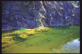
Cheating Pacheco Creek
The Santa Clara Valley Water District claims an algae problem as justification for a new reservoir that could encroach on majestic Henry Coe State Park, but opponents say it's all just a cover for putting development first and the environment second
By Najeeb Hasan
ON A SUNNY, BREEZY Tuesday morning in the southern hills of Santa Clara County, Bob Patrie's blue jeans are drenched up to his knees. As he splashes through a rust-colored stretch of Pacheco Creek along Henry Coe State Park's eastern border, the spry 58-year-old park volunteer takes on the challenging terrain with relish. This is why he's opted to work only four days a week at his San Jose employer, Xilinx Inc., and spend his Fridays at the park for the past 25 years. Even though he lives in Santa Cruz and takes advantage of the redwoods and beaches in his proximity, the rugged hills of Coe Park hold a special place in his heart.
With spring's rainfall, the normally placid creek is running a little bit swifter and deeper than usual. Indeed, the dancing body of water almost seems to revel in its unpredictability--for 20 yards, the best bank to walk along is on the creek's left side; then, for the next 40, the dry side appears gleefully on the right, forcing hikers to continually crisscross the creek and thus offer up their dry blue jeans, shoes and socks on Pacheco's sacrificial altar.
But Pacheco Creek, Patrie explains as he navigates, is more than just a picturesque feature of Coe Park for hikers to enjoy. Pacheco is one of Coe Park's three major rainfall drainages, the other two being Orestimba and Coyote creeks. It's a thriving wildlife corridor that supports a fragile ecosystem.
"Not only is it easier for us to walk up and down [because of the creek]," he says, "it's also here for animals to travel." He's referring to the bobcats, coyotes, jack rabbits, tule elk, eagles and even the San Joaquin kit foxes that make this protected habitat their home. Further, without the creek, much of the vegetation that grows alongside it would disappear. Sycamores that are accustomed to Pacheco's gentle flow of water toward Monterey Bay would no longer thrive and would be replaced with other trees that could. Already, because of a dam downstream and outside the park that creates the Pacheco Reservoir, steelhead trout, which used to spawn upstream in Coe Park, can no longer make it to their spawning grounds.
With his full head of wispy white hair tucked neatly under a fisherman's cap, Patrie's sharply creased eyes spot minute details along the creek path. He points out coyote droppings hidden behind rocks, drops to one knee to examine the different varieties of the park's wildflowers and grasses--yellow and red-spotted monkey flowers, scarlet pimpernel, Chaparral virgin's bower and yellow Johnny-jump-ups (he explains that about the only plant not native to Coe Park is its grass, which was introduced by the Europeans, and traveled across the Atlantic on the hooves and hides of their cattle and quickly overwhelmed the region's native bunch grass), then examines the concave bedrock mortars the Ohlones once used to grind acorns along the creek.
If the economy would shape up, Patrie says he would retire in a year or two so he could spend even more time at the park. Recently, he spent months creating a topographical map for the 86,000-acre park with the aid of a GPS system, a cartographer friend in Oregon and his own hiking know-how.
Patrie knows the strengths and failings of the land surrounding Pacheco Creek all too well. He knows them better, he is sure, than the Santa Clara Valley Water District, which is considering a project that, with enough political maneuvering, could submerge this particular section of Pacheco Creek in 50 to 70 feet of water. Bob Patrie is ready to stand in the floodgates, and he's not afraid to get wet.
Up a Creek: This map shows what environmentalists fear will happen, ultimately, to Pacheco Reservoir and to Henry Coe State Park if the Santa Clara Valley Water District pursues an expanded reservoir at this site, which has been detailed in past studies. The water district says it envisions a far smaller reservoir as a solution for getting more usable water for the county. Note: The small dark area at lower right shows the current size of Pacheco Lake.
Attack of the Green Slime
Word began to trickle out about a threat to Henry Coe State Park several months ago, after federally mandated meetings conducted by the Santa Clara Valley Water District (SCVWD) were held late last summer. The meetings were ostensibly to canvass community input about how to deal with excess algae in the San Luis Reservoir that interferes with the collection of water used by Santa Clara County--formally referred to as the "San Luis Reservoir Low Point Problem." The meeting flew under the radar of most area environmentalists and didn't garner much public interest.
Today, almost nine months later, advocates for Coe Park worry that the SCVWD is planning to heavily encroach upon the park for its solution by increasing an existing rainfall reservoir at Pacheco to 65 times its current size. In fact, about three weeks ago, the district revealed that building a new dam and thus creating a larger storage reservoir along the park's Pacheco Creek is still being actively considered (along with five other alternatives).
The district, however, says no final decision has been made, but if Pacheco were chosen for expansion, it would only grow to, at most, 25 times its current size and perhaps not encroach on the park.
Furthermore, opponents to the reservoir in Henry Coe contend that the "algae problem" is really a supply problem, one which has been worsened by sprawling development in South County and other areas of the valley. And that the district is using state environmental money, earmarked for solving environmental problems, to cause more of them.
The San Luis Reservoir, off Highway 152, is essentially a canal that stores and transfers 2 million acre-feet of water (one acre-foot of water is about the amount two families of five use in one year). The water arrives from the California Aqueduct and runs into the O'Neill Forebay, into the San Luis Reservoir and on to its customers.
Historically, Santa Clara County depended on groundwater to meet the region's water demands, but development and drought possibilities forced the county to locate more sources. Today, about 50 percent of Santa Clara County's water comes from groundwater, and the other 50 percent is imported surface water that comes from San Francisco's Hetch Hetchy Reservoir, the California State Water Project (SWP) and the federal Central Valley Project (CVP).
While the San Luis Reservoir was being built, the SCVWD, in an attempt to save money, decided to collect its water from the west end of the reservoir, which sits closer to the county than the California Aqueduct.
But in placing their intake pipe at this location, the district made itself vulnerable to what is now known as the low-point problem.
San Luis Reservoir is relatively broad and shallow. During the summer months, when water demand is higher and the level of the reservoir is lower (and sunlight is plentiful), conditions for algae growth become ideal. As the summer water demand begins to suck the reservoir dry, the concentration of the algae grows to a dense 30-foot-thick bloom in the reservoir, which gets into the intake pipe at such high concentrations that the water cannot be treated for the contamination.
Meanwhile, on the east end, a lower intake pipe takes water from the reservoir to most of its California customers. But the pipes used by Santa Clara County sit higher in the reservoir at the west end, where the reservoir floor slopes up. Here, two connected intake pipes--an upper intake and a lower intake--convey water to the powerful Pacheco Pumping Plant, which supplies Santa Clara and San Benito counties. (Santa Clara County is contracted for about 75 percent of the CVP water, and San Benito County gets the remaining 25 percent).
According to the SCVWD, there are institutional agreements between the users to ensure that the water in the reservoir never drops below the district's lowest intake pipe. Because of these agreements and the extra layer of water that the algae affects, the reservoir can never be drained, even during peak seasons, and an estimated 200,000 acre-feet of water is never used.
"That's a critical problem for California," says Karen Molinari, a Jones & Stokes community affairs specialist hired by the SCVWD to handle its Low Point Improvement Project. "How can we increase our operational flexibility and not have to hold this 200,000 acre-feet to protect our supply? We're in need of water everywhere. ... The state has to realize that we can't let 200,000 acre-feet just sit and not be utilized. That's half of the district's drinking water supply."
A new reservoir, the water district maintains, could be a viable conceptual solution to the low-point problem because it offers storage for surface water. The unused water in the San Luis Reservoir could be stored in a new reservoir and used when needed in Santa Clara County.
That Sucking Sound: This diagram of San Luis Reservoir, which currently supplies much of Santa Clara County's water, shows (at right) the two intake points leading to Pacheco Tunnel. Water district officials say the pipes are too high, and during the summer months when algae concentrations rise and water levels drop, the valley can't utilize its allotted water.
Environmental Eddy
At the heart of the debate between environmentalists and water officials lie what seem to be competing environmental concerns. For instance, another reason the San Luis Reservoir low-point problem has received urgent status in recent years is because of measures undertaken by the CALFED Bay-Delta Program, a coalition of local, state and federal agencies (along with other stakeholders, including the SCVWD) with the mission of improving the environmental health of the San Francisco Bay/Sacramento-San Joaquin Delta estuary ecosystem.
California's water system has major impacts on the delta, primarily because much of California's rainfall occurs north of the delta and much of the state's water consumption occurs south of it. The delta, then, is used as a sort of gateway that transfers the water from the north to the south. This artificial use, of course, has side effects, some of them being that salt water from the bay gets backed up further into the delta and that the rivers start running backward, confusing the fish. CALFED wants to find ways to get more water pumped through the delta but lessen the environmental impact, and because the federal government is involved, its projects have to meet federal environmental standards.
CALFED, in measures that, for example, would protect the spawning runs of fish who use the delta to travel up the rivers, enacted rules that changed the delta's water-distribution schedules. At certain times of year, water transfer through the delta is prohibited. The change in the water-delivery schedule coincided with the peak demands of the Santa Clara Valley Water District, in a sense, making the SCVWD depend more on the 200,000 acre-feet of water sitting uselessly in the San Luis Reservoir because of the low-point problem.
In environmental terms, because the changing pumping patterns of water from the delta could potentially produce water-quality problems for Santa Clara County (because, if Santa Clara County demand gets high enough during peak season, the county might be forced to depend on algae-contaminated water), the phenomena is considered an indirect impact, or a possible future impact.
CALFED, again, is ostensibly an environmental coalition, and one of its guiding principles is not to cause redirected environmental problems because of its projects; if it does, the coalition must provide funding to mitigate the environmental problem.
This, in turn, helped (along with many other factors) result in a $14.8 million grant to the SCVWD to conduct a feasibility study for a solution for the San Luis low-point problem. The main solution considered, when the grant was doled out, was the most obvious: a bypass (much like a bypass around an artery clogged with plaque) to divert water around the algae-clogged San Luis Reservoir that would take water from the O'Neill Forebay directly to the SCVWD intake pipe.
But because CALFED has both state and federal concerns, any project must meet both levels of environmental standards. State standards require the SCVWD not only to look at the bypass option in their study but also to examine any other reasonable alternative, which is where the idea of expanding Pacheco Reservoir came up: ironically, leaving other possible environmental problems in its wake.
Dam Shame: Park activists fear a reservoir that encroaches on Henry Coe State Park would not only be illegal but also erase a scenic valley that is home to undisturbed wildlife, vegetation and traces of Ohlone Indian civilization.
Reservoir Dogs
Environmentalists, of course, think the district is using subterfuge to get what it wants: a second holding reservoir fewer than 10 miles from San Luis Reservoir.
At last summer's public meetings, the Santa Clara Valley Water District came up with 75 preliminary alternatives to the low-point problem. These alternatives, at the time, were never disclosed to the public, but months later a list of 16 revised alternatives (narrowed down from the original list of 75) was released. Included in these alternatives were three controversial plans: one for a larger reservoir on the Pacheco Creek site, one for a reservoir inside Henry Coe State Park and plans for enlarging the existing Anderson Reservoir by raising the height of its dam.
Then, about four weeks ago, a winnowed-down list of six alternatives was released. Both the Anderson Reservoir project (which would threaten private property owners as well as Coe Park) and the new reservoir inside Coe Park were dismissed, but the Pacheco Creek site remained.
Other alternatives include a required "no-project plan;" a complicated option requiring two alternatives to be combined with another alternative (algae management and air-flotation treatment that raises algae to the surface of the reservoir); a bypass corridor (viewed by environmentalists as the most practical on the list); and unspecified regional solutions for importing more water (for example, receiving more water from San Francisco's Hetch Hetchy Reservoir).
Also, another option still on the table, an official representing the SCVWD says, is to simply lower western Pacheco Pumping Plant intake in the San Luis Reservoir (though that would require the lowering of the entire pumping plant, not just the pipe).
However, the question for Dennis Pinion, an engineer who, like Bob Patrie, is a longtime Coe Park volunteer, is why the Pacheco Creek site is still being considered as a reasonable alternative when making the reservoir 25 times larger (although Pinion believes the district is ultimately angling for a 65-fold increase) could encroach upon the pristine wilderness of Coe State Park. And he thinks it's because the district wants it there--and has all along.
"From the beginning," Pinion says, "Pacheco for them was the most desirable of alternatives. ... I think they picked the Pacheco Reservoir site because it was the most convenient. The fact that it happened to intrude upon the park was of no consequence. Basically, they're starting with a solution and designing an environmental impact report that leads to that solution. We're beginning to get the district's attention, and they're beginning to realize that their current direction will not succeed. But how they go from this point, I don't know. They may decide they will keep pushing. So far they haven't come up with any statement saying they would stay out of the park. On the contrary, they've eliminated viable options, which leaves them almost already decided."
The two reservoir options (Anderson and Coe Park) that would blatantly inundate both the park and property owners with water, environmentalists believe, were diversionary tactics to detract attention from the preferable Pacheco Creek site.
"It's a standard trick," says Jason Kibbey of the San Franciscobased public land protection group Defense of Place. "You pick one alternative and then display a set of alternatives that are egregiously out there. You can focus in on your preferred alternative and look like the good guy by removing the egregious alternatives and going for the preferred alternative, whether or not that alternative is damaging."
Building Frenzy
But why, many wonder, is a reservoir needed to solve an algae problem in the San Luis Reservoir, and why do environmentalists believe the SCVWD has intentions to expand the Pacheco Reservoir into Coe Park?
Park advocates say the Pacheco Creek site is being considered because the SCVWD is not thinking in terms of solving the low-point problem but in terms of using that problem as an excuse to build a large reservoir that would address the county's long-term water needs.
Approving the construction of a reservoir, with modern-day environmental regulations, is for more difficult today than it was in the past. Kibbey recalls a story an old-time environmental activist told him. "He said, when he first started working on dams long ago, the Army Corps of Engineers had 650 projects it was working on. Then, seven or eight years ago, he checked back, and only two dams were being built in this country. Thirty or 40 years ago, it was a veritable dam frenzy."
Further, the district's 1999 Integrated Water Resources Plan (IWRP) states: "The 1997 IWRP identified several options for increasing surface storage of excess imported and local water during wet years. Further investigation of these options is not recommended due to the increasing difficulty of obtaining project approval in the current regulatory environment. However, the district will continue to monitor opportunities for additional surface storage."
A year later (environmentalists contend), an opportunity showed up, one that the state and feds would approve and possibly even help fund. Pinion says: "The point is, they're [SCVWD] looking for where to put a reservoir. The San Luis low-point problem was an opportunity to do it surreptitiously when they can't do it heads up."
Dam Foolishness
Much of the criticism of SCVWD's intentions derives from information gathered from a little-known 1993 reconnaissance study of alternative dam and reservoir sites prepared for the district by Wahler Associates. A reference to the reconnaissance study was included in a list of background and reference materials for the low-point problem that the SCVWD provided in response to Pinion's public information request.
The SCVWD, however, insists that the Wahler study is a dusty report that has very little bearing on the current project--even though the district has been unable to provide a more current report that actually examines the Pacheco Reservoir site.
The existing Pacheco Reservoir currently has the small capacity of 6,143 acre-feet, but its advantage to the district is that, geographically, the reservoir is located very close to the Pacheco Conduit, the pipeline that carries raw water from the San Luis Reservoir, under the Pacheco Tunnel and into treatment facilities that prepare the water to be distributed to Santa Clara and San Benito counties. Thus, very little new pipe would have to be laid to enlarge the reservoir with Central Valley Project water. In the reconnaissance study, two options for Pacheco are examined: an "upper Pacheco" site and a "Pacheco B" site. Because the Pacheco B site would encroach (in the worst-case scenario) about half a mile less into Coe Park (than upper Pacheco), Pinion believes that is the option the district is most interested in.
"We're not trying to deceive or trick people into [letting us get] away with something." says Kurt Arends, the water district's Low Point Improvement Project manager. "We would love nothing better than to reassure people we won't touch the park. It's not my job to judge what's better, what's not, but there's a good opportunity to do the project and not affect the park."
While a reservoir with the capacity of fewer than 150,000 acre-feet may not encroach the park, Pinion believes the district desires a larger reservoir, somewhere between 300,000 and 400,000 acre-feet, to meet long-term needs.
A reservoir this size could extend nearly two miles along Pacheco Creek into the park and flood 1.6 miles of North Fork Trail in the park's backcountry.
Giving credence to environmentalist worries about a new reservoir is the fact that, in the district's 1997 Integrated Water Resources Plan executive summary, the need for a large reservoir is highlighted. In one section the feasibility of a new reservoir of 550,000 acre-feet (with an undetermined location) is discussed, while in another section of the same report a 350,000 acre-foot reservoir is suggested as a key component of future water resource strategy. The 1993 reconnaissance study, meanwhile, indicates that all the reservoir alternatives were "sized to accommodate a relatively large volume of imported water." Also, because the cost of building a reservoir decreases as the acre-footage of the reservoir increases, a larger reservoir would be more economically efficient. According to the study, a 400,000 acre-foot reservoir on the Pacheco B site would have a unit storage cost of $819 per acre-foot, compared to a 150,000 acre-foot reservoir, which would top out at $1,337.
"I can see how an expanded Pacheco Reservoir would fit into the district's water-resource plan for allowing storage beyond the year 2020, but I don't see how it is a solution for the San Luis low-point problem," Pinion says. "Their problem right now is they don't really use all the water they're legally contracted to get, so they'd like to save it for a rainy day--or the opposite of a rainy day. They'd like to store their excess water. This is beyond the scope of the bypass problem. It gets into meeting long-term objectives beyond 2020."
Water Under the Bridge
But if the district is trying to meet long-term water needs beyond 2020, would it be doing something disingenuous by using the state's money to "study" its current low-point algae problem?
The Santa Clara Valley Water District maintains its intentions are pure. A high-capacity reservoir to meet Silicon Valley's future needs is not only beyond the scope of solving the low-point problem but would also entail receiving different sources of funding and environmental approval, says Arends.
"We can't do that [build a reservoir to meet future water needs]," adds Mike Di Marco, a media coordinator for the district. "That's not part of this project. We'd have to start all over ... with new stakeholders, new public input. I don't think the district feels we have any type of entitlement to a [new] canal or reservoir."
Arends says that preliminary studies of the Pacheco sites and an estimation of the project's need for storage would hold any reservoir being considered at the site at a maximum capacity (in the worst-case scenario; in the best case, a Pacheco Reservoir could be combined with one of the other alternatives to produce a much smaller reservoir) of 150,000 acre-feet, a size that, quite possibly, would not affect the park. Depending on the size and location of the dam, a 150,000 acre-foot reservoir could encroach about 30 acres into Coe Park, a much smaller figure than the park's advocates, relying on the 1993 reconnaissance study, are using.
"We don't know if the project would impact the park," Arends says. "There are alternative dam sites [for example, the dismissed Anderson site] that would impact the park. I can't guarantee that there's no way we could do it without [encroaching into the park]. Typically, the impacts are analyzed in an environmental review process. We're only in feasibility right now. If one of those impacts was impacting a state park, we'd discuss here how we could avoid that or mitigate it."
Pinion, meanwhile, remains unconvinced, and notes that the district's planned environmental impact report will acknowledge the possibility of expansion at the Pacheco site. "It's not [difficult] to get environmental approval to build a larger reservoir," he says. "You get approval for a 150,000 acre-foot reservoir. You come back one or two years later before building the reservoir with another project funded from another source that provides for a project for long-term needs. You study your reservoir sites and come to the conclusion that a much better solution would be to put it into the Pacheco Creek site. They already got a foot in the door."
[ Silicon Valley | Metroactive Home | Archives ]
![]()
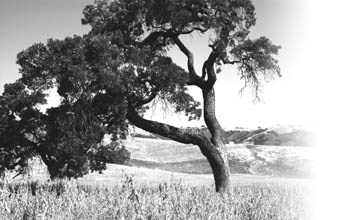
Photograph by Deborah Dennis

Source: Bob Patrie

Source: Santa Clara Valley Water District
Photograph by Ron Fischler

Keep It Flowing: Pacheco Creek, currently being eyed for a reservoir by the Santa Clara Valley Water District, is one of the three main drainages for the 86,000-acre Henry Coe park. The water district says that only 30 acres of the park would be affected.
Send a letter to the editor about this story to letters@metronews.com.
From the May 15-21, 2003 issue of Metro, Silicon Valley's Weekly Newspaper.